|
Tipton, Oklahoma Tornado and Storm Structure |
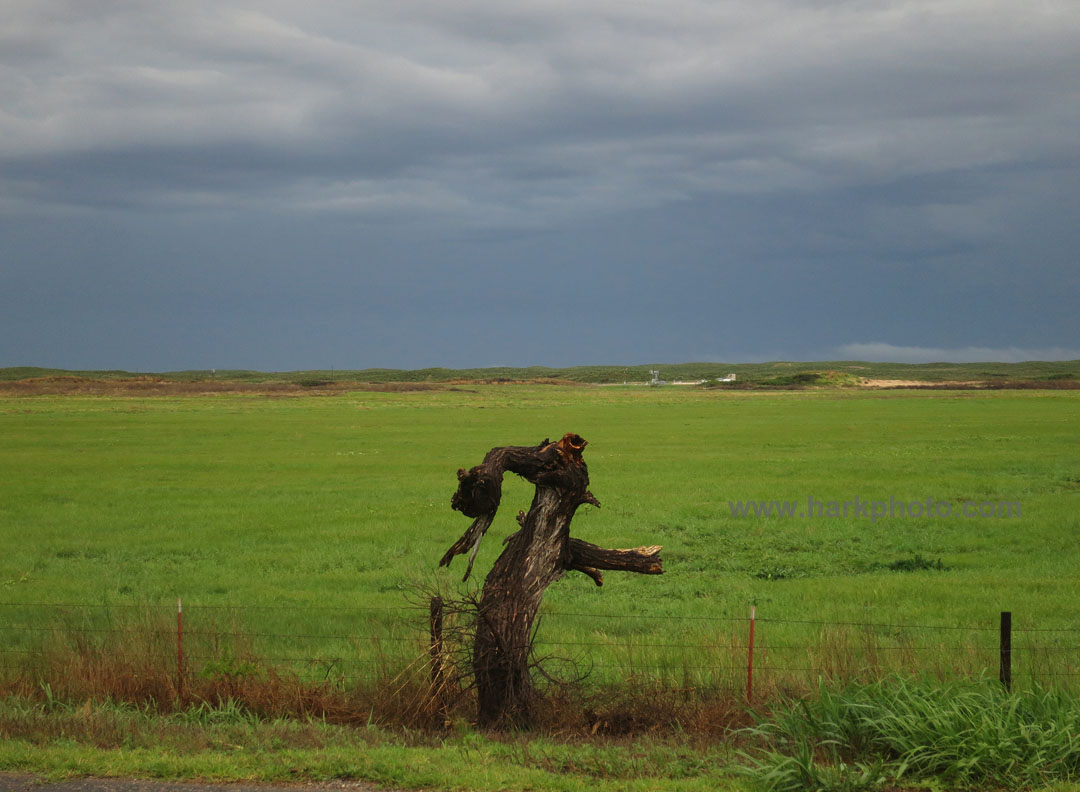
Wide View of Tornado near Tipton |
This was the tornado outbreak day that had been hyped for several days. The Storm Prediction Center had issued a Moderate Risk that extended across a large area from central Nebraska to the Texas border. There was the potential for multiple tornadic storms with “strong long-tracked” tornadoes. I had two potential target areas: southern Kansas near Greensburg to Pratt and southwestern Oklahoma. Unfortunately, I had only made it as far as Colby, Kansas from the previous day's grueling chase from Salina, Kansas to Bridgeport, Nebraska in the panhandle. I was out of position for the southern target unless I left early. I was able to get out of Colby by 8 AM, early, but not as early as I had originally planned due to a massive sleep deficit. I had to get south and the target could be finalized on the road.
I headed east on I-70 and then south at Wakeeney, Kansas on 283. Near Dodge City, I encountered heavy rain that was slowly shifting to the east. The atmosphere was getting “worked-over” and after checking additional data, I decided that it probably wouldn't recover in time to generate decent storms. Despite a continuation of the Moderate Risk, I blew off the northern target in Kansas and continued toward southwestern Oklahoma. Time was critical as I expected storms to fire early. I planned on stopping in Sayre and reassess the final target. In Laverne, Oklahoma, I had a quick lunch (pizza from a gas station) and reviewed more data. Storms were already starting to fire in Texas. I continued south, enjoying nice views of wildflowers under asperatus clouds. There was no time for an extended photo stop. One of the storms southwest of Shamrock, Texas had already become tornado warned. This was too early. I was regretting not getting up earlier but I needed the sleep. I continued south and stopped in Erick, Oklahoma near the Texas border. The tornado-warned storm was approaching. With no decent road options, I just waited. A long north-south line of mushy storms had formed, all competing for energy and reducing their tornadic potential. The main storm was becoming linear. I saw on various social media that the storm had produced a nice tornado southwest of Shamrock, Texas. Maybe that was it, and the chase day was over prematurely. I watched this approaching line but none of the storms were becoming isolated. After waiting for maybe too long in Erick, Oklahoma, I noticed that the terminus of the line was slightly stronger and would eventually move across the Red River into Oklahoma and into a better environment. I blasted south toward Hollis, just ahead of the developing line of storms. One caught up to me in Hollis, and I was subjected to brief heavy rain. I turned east on 62. The southern storm was intensifying as it moved mainly east and to my south. My plan was to drop south at Altus and get ahead of it. The forward speed of the storm increased, and I was seeing reports of hen's egg to softball-sized hail. When I reached Altus at 5:19 PM, the storm was almost on my south option. I could chance dropping in front but I would likely be cored by the storm and likely getting smashed by hail or worse, drive into a tornado. Years ago, I might have risked it, but I am a bit more cautious now. Instead, I drove further east to get ahead of it. I had to drive all the way to Snyder for a decent road south. The few earlier south options were dirt and mud. At Snyder, I turned south on 183, then back west on 5c toward the town of Tipton. The massive storm was looming in the distance. There were reports of a large tornado near Elmer and I was painfully too far away. I passed Tipton and continued west directly toward the storm. The structure was amazing, twisting into the air. The one road was crowded with chasers and locals. Due to poor visibility and the one road, I didn't want to get too close. I stopped west of town and peered into the darkness. I could barely see a large tornado that appeared to be heading toward me before starting to shift to the north. Judging distance was difficult due to rain and I didn't want to risk getting closer. The cone tornado became more of an elephant trunk in shape as it moved north of the road and contrast improved slightly. I shot some more video before I had to move back east due to the blasting RFD winds. The tornado was wrapped in rain. Progress was slow due to the number of cars and the stop sign at the intersection with 183. I turned north on 183 and resumed going east on 62. The storm was shifting north of the east-west road. I couldn't see the tornado but the storm structure was amazing. The core had a weird blue glow. The area was hit with multiple cloud to ground lightning strikes. I stopped several times to take pictures from inside the car due to the lighting danger. I followed the storm eastward toward Lawton. As I neared town, there were more spotter reports of a tornado to my north, but I couldn't see anything. I decided to end the chase and head northeast on 44. There were more tornadic storms to the south, but I wasn't interested in attempting an intercept after dark. I arrived in Norman and observed a brief blast of hurricane-force winds as the line of storms passed by my location. I enjoyed the traditional post-tornado intercept steak dinner and was off to bed for much needed sleep.
This was a fun and exciting storm chase. I am bummed that I missed the initial high contrast wedge tornado (a bit of tornado envy after seeing the pics on Twitter, Facebook and other social media), but also happy that I did see a tornado and beautiful storm structure. I did hear that many storm chasers who got too close had all their windows smashed by baseball hail. The tornado was later rated EF-2.
 |
 |
National Weather Service (Norman, OK) Preliminary Report
Go to May 17-18, 2015
Return toMay 15, 2015
Return to Storm Chase 2015