Storm Chase June 10, 2013: Tornado in Amelia County, Virginia near Jetersville
chase images and log by William T. Hark, M.D. Video (HD) and pictures available for licensing. Click on images to enlarge
HD storm chase video of the Jetersville (Amelia County), VA tornado
|
I had been watching the approaching system for a few days and was expecting the possibility of severe weather in the Mid-Atlantic region. There was decent upper level support with a mid-level trough approaching the area. There was a 500mb southwesterly wind of 35 kts during the day and higher speeds expected toward the evening. At the surface, dewpoints were in the 70's. By 1 PM, there was a band of SB CAPE of 2500 through central Virginia and a localized EHI bullseye of 3 near Lynchburg. The best backing of the surface winds were along the front in Maryland, but that area was too far to reach in my limited time after work and would be difficult to chase due to metropolitan area traffic. The models and surface observation suggested the possibility of some backing of surface winds in central Virginia. My main concern in this area was cloud cover and the potential for many storms developing at the same time. The 6hr HRRR 1-6 km maximal updraft helicity showed a more isolated rotating storm in Campbell and Appomattox counties by 6 PM. This was just west of Farmville. The reflectivity showed the storm as a part of a second mass of storms but somewhat ahead and more intense. The WRF showed more of a line farther to the west. I did expect a second line of storms to rapidly develop, therefore, I wanted to get on any storm early. My target was the Farmville to Appomattox area.
I left my office in the early afternoon and headed west on 64 before dropping south on 288. I then turned west on 60 through Powhatan County. At Sprouses Corner, I turned south on 15 toward Farmville. There were scattered storms forming to the west and coalescing, but I was most interested in more intense and isolated development southwest of Farmville. I blasted south and reached Farmville by approximately 5:10 PM. Although fairly cloudy, I could see the edge of the updraft to the southwest beyond the buildings of Farmville. I had a great approach via 15 south of the town. The road network was not good, but I could drop in front of the isolated storm and let it pass to my north. I continued south on 15. Visibility was terrible due to trees. Unlike many parts of Virginia with extensive cultivated fields and pastures, this area was forested. The storm became tornado-warned at 5:20 PM including for Hampden-Sydney College. I was just to the east and was dropping south. I passed the entrance to Hampden-Sydney and continued south near the Briery Creek Lake. That would have been a great view but the storm was already too close and was already passing the lake. I could catch occasional glimpses of a wall cloud through the trees. I stopped by Patrick Henry Rd at 5:30 PM and let the storm pass to my north. There were no decent east options. I had to turn around and go back north through the back side of the storm and attempt another intercept farther east. Unfortunately, more storms were developing to the west of the main storm. This storm was moving northeast at 35 miles per hour. I drove north on 15, then east on 460 bypassing Farmville. I was on the north side of the storm trying to get ahead of it. At 5:50 PM, I continued on 307 (Holly Farms Rd), and I eventually got ahead clear of the rain. The storm was to my south and approaching the road. I briefly stopped at State Rd 617 (Saylers Creek Rd) by the Prince Edward and Nottoway County border, and I could see a ragged somewhat linear wall cloud just to my southwest by 5:57 PM. After a few minutes of observation, I continued east. I stopped again at 6:04 PM and the wall cloud was better formed and quickly overtaking my position. I drove east on 307 and let the storm pass to my east and to the north of the road. I stopped at the entrance to the Tyson plant just over the Amelia County border where I had a great view to the north. I was on 307 .8 miles west of 360 and 2.5 miles southwest of Jetersville, Virginia. Although I was in rain, I could see a slight lowering at 6:12 PM. By 6:13 PM, I could see a definite elongated and rotating wall cloud to the northwest. A funnel formed and definitely reached the ground at 6:14, though I suspect it may have been down earlier. I watched the weak and ragged tornado shift to the northeast. It dissipated by 6:16 PM. Contrast was poor. I continued eastward on 307 and northeast on 360 following the storm but it had weakened as it merged into a large mass of storms. The chase was over. I continued back to Richmond.
The tornado that I observed was later rated as an EF0. I am glad that the tornado was weak and stayed over a relatively unpopulated area. This is an interesting part of Virginia for me as I have family who lived or live in areas just to the west of my chase route, and one relative who fought in the War Between the States aka Civil War at the nearby Sailor's Creek Battlefield. Total miles: 146.

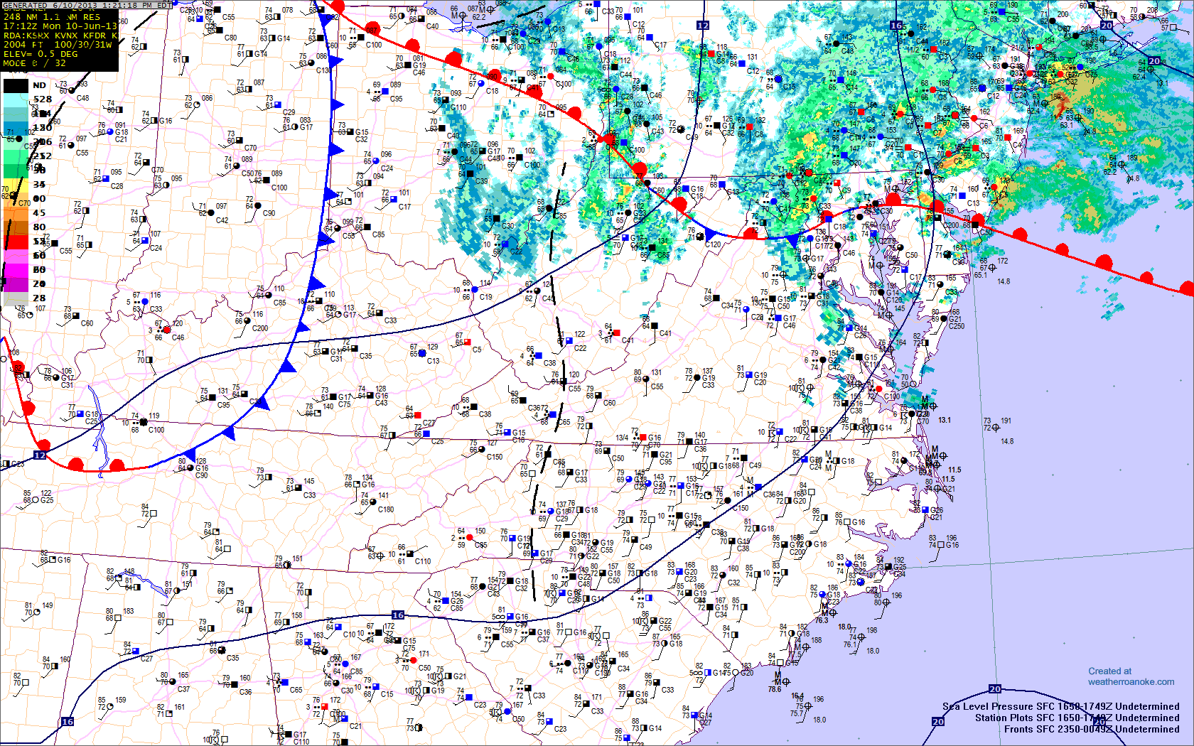
XM Radar Image, 5:05 PM EDT
|

Storm over Farmville, VA 5:12PM
|

Storm, 5:57 PM
State Rd 617 (Saylers Creek Rd)
|

Storm, 5:57 PM
|

XM Radar Image, 6:00PM
|

Storm, 6:04 PM
|

View from Tyson plant driveway
Holly Farms Rd (307) 6:12 PM
|

Wall cloud, from Tyson plant driveway
Holly Farms Rd (307) 6:13 PM
|

Tornado, from Tyson plant driveway
Holly Farms Rd (307) 6:14 PM
|

Tornado, 6:15 PM
|

Tornado, 6:15 PM
|

Tornado, 6:15 PM
|

Tornado, 6:15 PM
|

Storm, from Tyson plant driveway
Holly Farms Rd (307) 6:17 PM
|

XM Radar Image, 6:25 PM
|

Storm, 6:27 PM
|
GPS Chase Maps with Observation Points and Tornado Track
Archived Weather Data
Go to May 31, 2013: El Reno, Oklahoma tornado
Return to Storm Chase Logs
Return to Storm Chase 2013
All images Copyright 2013 William T. Hark


