

|
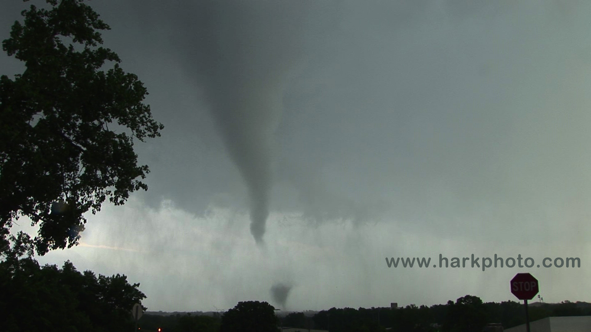
Edmond, Oklahoma tornado and reformation east of the town |
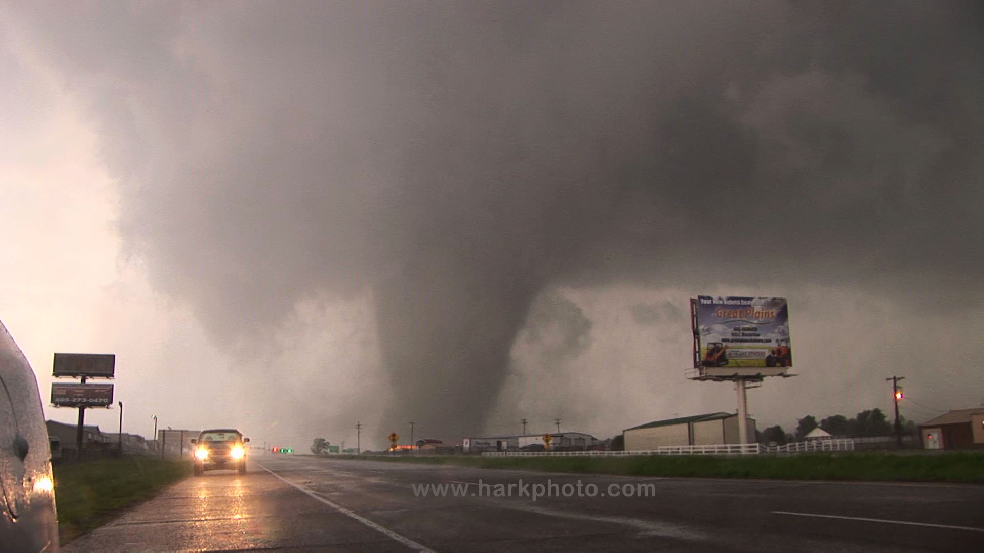
Shawnee, Oklahoma tornado |
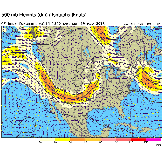
A potential severe weather outbreak was forecast for central and eastern Oklahoma and Kansas extending into Missouri. The SPC had issued a moderate risk with 15% risk of tornadoes for portions of that risk area. There was a broad area of 50-60 kt SW winds at the 500mb level and significant forecast instability. The cap would be an issue especially toward the south into Oklahoma. At the surface, there was a low over the eastern Oklahoma panhandle/southwestern Kansas and generally southeastern surface winds from central Kansas into Oklahoma. Based on model precipitation forecasts, I had two target areas. One was in southern Kansas east of Wichita and the other in central Oklahoma. Storms would be more isolated further south. The northern target was the southern part of a “blob” of forecast precipitation. I liked the high potential EHI in central Oklahoma and more southerly 850 mb winds. I split the difference and targeted the exit of 11 on I-35 near Blackwell Oklahoma. I could quickly head north or south depending on how the situation evolved
I started the chase day in Blackwell, Oklahoma, and waited by the I-40 exit at a gas station. Several other chasers dropped by including Amos Magliocco. Waiting can be difficult as one has to resist the urge to go after the first storms that develop. As expected, storms started to form just west of Wichita. Heading north was very tempting, but I decided to wait for more isolated storms to the south. Eventually, there was development near Oklahoma City and also west of Alva. I decided to drift south. By 3:13 PM, I had heard of tornadoes near Wichita, but I was committed to a more southerly target. The back edge of a storm near Oklahoma City was already visible. I was south of Guthrie by 3:34 PM. The storm north of Oklahoma City was already showing some rotation, and at 3:40 PM, there was a severe warning for that storm. The center was near Piedmont; moving northeast at 30 miles per hour. I turned west onto the Kilpatrick at 3:47 PM. There were great radio updates on the storm's progress. At 3:48 PM, I could see a wall cloud. According the radio, there had already been a brief tornado. I turned onto 77 N at 3:49 PM. My progress was slowed due to traffic lights and traffic in Edmond. Navigating was also difficult due blocked roads from construction. The meso was approaching Edmond, and I could hear the tornado sirens. From an Edmond shopping center parking lot at 4:11 PM, I could see significant rotation in the clouds. This was too close. I managed to shift east on 2nd Street reaching Boulevard at 4:18 PM. Finally, there was less traffic and stoplights. There was a report on the radio that rotation was increasing and the storm “tightening.” I found a parking lot on a hill just east of Edmond, and I could see tornado at 4:23 PM. I had a great view due to the hill. A huge cross gave an interesting foreground. While watching the tornado, one of the onlookers was doing handstands. Very strange! Swirling debris were visible under the funnel including trees and a weird “ribbon” that stayed aloft for a couple of minutes. I watched the tornado until 4:29 PM, then I shifted east to reposition. The tornado was to my south. I headed east on E. 2nd Street that becomes 66. I was in the rain. Visibility was terrible due to hills and trees. I wanted to get ahead of the storm before the meso would shift across the road to the north. According to the radio announcer, another funnel was visible at 4:34 PM but I couldn't see anything. I briefly stopped at a gas station with a weird giant bottle-shaped wire sculpture. I was still in rain but the storm was shifting north of 66. I passed Arcadia at 4:37 PM and could see rotation in the storm. The rain in my location had ended. I was trying to get ahead of the storm. The chaser and local traffic was annoying and slowing my progress. I continued east and could see a rotating wall cloud through a clearing and possible funnel. I stopped. There was a debris whirl under the wall cloud at 4:44 PM to my northwest and a well-defined tornado by 4:47 PM. Viewing was miserable due to the large number of cars on 66 crossing my view. After watching the tornado, I headed west to keep ahead of the storm. More trees and hills blocked my view of the tornado. There was a nice inflow band to the northeast. I crossed into Lincoln County at 4:53 PM. In a clearing, I could see a distant wedge tornado. I briefly took video at 4:58 PM with a decent view of the tornado. I should have stopped longer to take video, but I wanted to get ahead and closer to the tornado. I continued east, then turned north on 177 at 5:03 PM toward Carney, Oklahoma to catch the tornado crossing the road. Heavy traffic slowed my progress. I passed a Doppler on Wheels (DOW) parked on the side of the road. Trees and rain impaired my visibility, and I didn't want to get too close to the approaching tornado from the west. I could see wrapping rain curtains to my north, and the tornado crossed at 5:09 PM. I stopped at 5:10 PM but couldn't see much more than rain and a faint darkening where the tornado should be. I dropped south but decided that I could not follow the tornado further east and north. There was also a more interesting storm to my south. The wedge tornado that I tracked toward Carney was rated EF3. The Edmond tornado was rated EF1. Luckily, there was only minor damage and no significant injuries in the Edmond area. I may have missed a brief EF0 tornado southwest of Arcadia.
Additional tornadoes from the Edmond storm as it moved toward Carney, Oklahoma
Chase maps of the Edmond, OK tornado and additional tornadoes from the storm

|

|

|
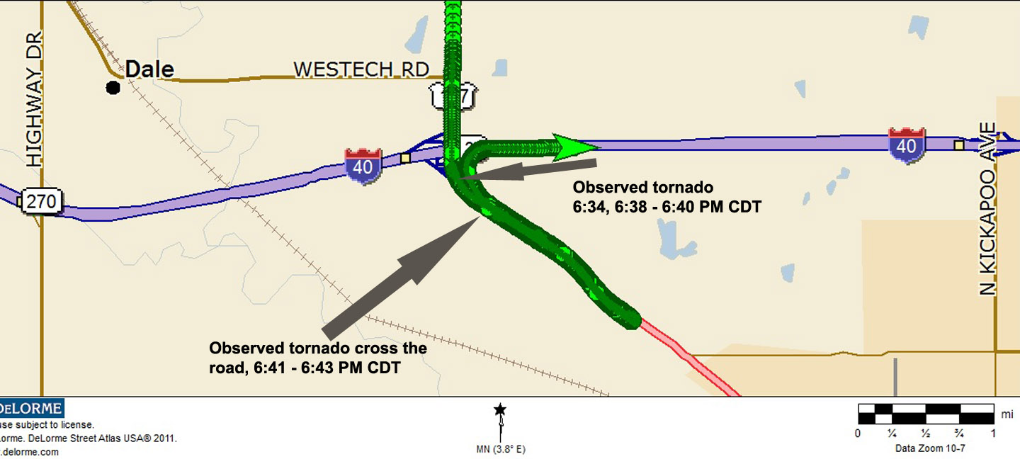
I drove south after my encounter with the Carney tornado targeting a storm that would eventually move near Shawnee, Oklahoma. I passed an interesting LP storm on my way to the larger “Tail-end Charlie.” State Road 102 was a nice quick route southward. I turned onto 62 from 102 at 6:07 PM, then I continued south on 177. Soon, I could see the edge of the storm. I reached the junction of 177 and 40 at 6:20 PM. I dropped a bit further south looking for a safe place with good visibility. The storm was to the northwest. I watched a large tornado and wall cloud from 6:26 PM to 6:28 PM before shifting north a bit for a better view. I parked by a stoplight near the on ramp to I-40 at 6:34 PM. The tornado was approaching from the west. The police were waving people out of the area. After a couple of minutes, I dropped south again on 177, then back to my original position at 6:38 PM. I parked and watched the large violent tornado. Due to the angle of approach, judging the potential track of the tornado was difficult. I expected it to cross the road to my north. As the winds increased, I was concerned about some large flimsy signs that could dislodge and fly in my direction. I dropped back south a bit and watched the tornado cross 177 from 6:41 to 6:43 PM. I could easily hear the roar of the tornado as I filmed while crouched outside by my vehicle. It sounded like a waterfall, not the stereotypical freight train. The tornado became wrapped in rain. I watched another wall cloud to my north for a while before continuing east on I-40 at 6:57 PM. The previous tornado was from the leading mesocyclone in a large storm. At 7:14 PM, I turned north on 99 toward Prague to intercept another mesocyclone but couldn't see anything due to rain. I stopped 7 miles from town and turned back south and continued east. I watched another wall cloud on the storm to the north but no tornado. While watching the storm to the north and west from an overpass on I-40, I ran into Rocky Rascovich and some other chasers. We watched the storm for a few minutes before I decided to continue east of I-40. At 8:12 PM, there was a new storm to my north that was tornado-warned. Visibility was difficult due to hills and trees. I couldn't see much and after a few attempts at finding a decent viewing place, I ended the chase and stopped for the night at a rather drab and worn hotel in Henryetta, Oklahoma. The tornado near Shawnee was later rated as EF4. It caused extensive damage and killed two people. The tornado and the victims have been mostly forgotten after the events in Moore the following day.
Chase Map Shawnee Tornado
|
Go to May 20, 2013
Return toMay 18, 2013
Return to Storm Chase 2013


 Wall cloud, 3:47 PM


